Typhoon Maysak Moving Through Okinawa

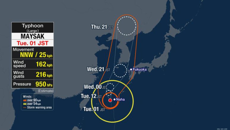
Powerful Typhoon Maysak is moving through the islands of Okinawa, southern Japan. It is expected to approach Okinawa's main island by Tuesday morning and move over waters west of Kyushu region through Thursday.
Weather officials say that as of midnight on Tuesday, the large and very strong typhoon was moving north-north-west over waters 80 kilometers south of Okinawa's Kume island at a speed of 25 kilometers per hour.
It has an atmospheric pressure of 950 hectopascals at its center. It is packing winds of 162 kilometers per hour with a maximum momentary velocity of 216 kilometers per hour.
Violent winds of more than 90 kilometers per hour are blowing within 185 kilometers of its center.
Maximum gusts of 156 kilometers per hour were recorded in Tokashiki island, 152 kilometers per hour in Nanjo, 148 kilometers per hour in Uruma, and 143 kilometers per hour in Naha.
Winds strong enough to cause houses to collapse are expected in Okinawa on Tuesday morning.
Winds of 180 kilometers per hour are forecast for the Okinawa region, and 90 kilometers per hour for the Amami region of Kagoshima Prefecture. Maximum gusts could reach 252 kilometers per hour in Okinawa and 126 kilometers per hour in Amami.
Rough seas are also expected. Waves are likely to reach 13 meters high around Okinawa, and 10 meters in height around Amami.
Okinawa is forecast to have hourly rainfall of 80 millimeters or more, accompanied by thunder.
By Tuesday night, up to 300 millimeters of rain is expected in Okinawa, 150 millimeters in Amami, and 100 millimeters in southern Kyushu region.
The approaching typhoon could cause a record high tide in Okinawa and may cause flooding in coastal areas and near the mouths of rivers.
Weather officials are calling on people to be alert for violent winds, high waves, landslides, flooding in low-lying areas and swollen rivers.
People are advised to stay updated on the latest information.


