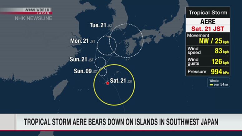
Tropical Storm Aere Approaching Southwestern Japanese Islands

Tropical storm Aere will be approaching the southwestern Japanese islands of Okinawa and Amami through early Sunday morning.
Weather officials are calling on people in the areas to brace for strong winds, high waves, and possible landslides.
The Japan Meteorological Agency says that as of 9 p.m. Saturday, Aere was 40 kilometers east-northeast of Naha in Okinawa Prefecture. It was moving northwest at a speed of 25 kilometers per hour.
Weather officials say the storm's central pressure was 994 hectopascals. It had a maximum wind speed of about 83 kilometers per hour, with gusts of 126 kilometers per hour near its center.
The storm may approach the southern main island of Kyushu on Monday or later.
Officials are forecasting torrential rains in Okinawa and Kagoshima prefectures through Sunday, with up to 70 millimeters of rainfall per hour near Okinawa's main island on early Sunday morning.
Up to 200 millimeters of rain is expected in the 24-hour period through Sunday evening. Up to 100 millimeters is expected in the Amami Islands.
The storm may bring violent winds, depending on how it develops. Maximum wind velocity could reach 126 kilometers per hour in those areas.
Seas will be rough, with waves as high as 6 meters around Okinawa's main island and the Amami Islands.
Weather officials say the storm could change course to a westward direction, and may approach western and eastern Japan between Tuesday and Thursday after moving northward in the East China Sea.
They are warning people to watch out for high waves, landslides, strong winds, flooding of low-lying areas, swollen rivers, lightning strikes and sudden gusts of wind.