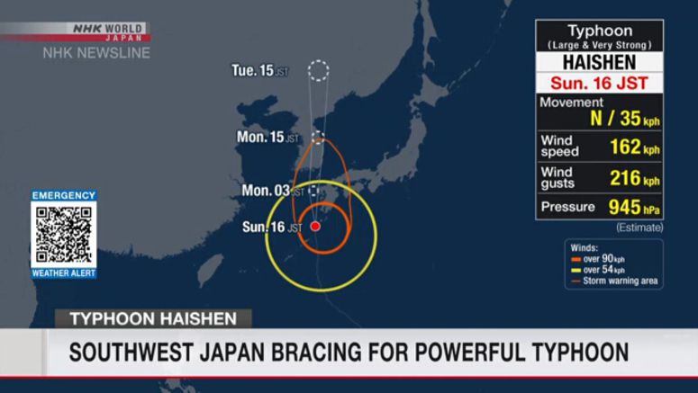
Southwest Japan Bracing For Typhoon Haishen

A powerful typhoon, possibly the strongest in decades, is battering the country's southwest.
As Typhoon Haishen draws closer, authorities are warning of potentially record rainfall, unprecedented wind, high tides and large ocean swells.
They're calling on people to stay on the highest alert and evacuate promptly if advised to do so.
Nakamoto Yoshihisa of the Japan Meteorological Agency said, "Typhoon Haishen is very powerful, as powerful as several typhoons that hit Japan last year. The agency urges people to be on the highest alert for record heavy rain, violent winds, high waves and storm surges."
Weather officials say that at 5 pm on Sunday, Typhoon Haishen was 70 kilometers west-southwest of Yakushima Island in the Pacific. They say it was moving north at 35 kilometers per hour.
Haishen has a central atmospheric pressure of 945 hectopascals. The typhoon is packing maximum winds of 162 kilometers per hour near its center - and gusts of up to 216 kilometers per hour.
Heavy rain is falling not only in areas where the typhoon is approaching, but also in wide areas of Japan, including those far from the typhoon. Authorities are warning of landslides, swollen rivers and flooding in low-lying areas.
Officials in several prefectures of Japan's southwestern Kyushu region have issued evacuation orders to local residents.
Over 30,000 households in Okinawa and Kagoshima Prefectures had no power on Sunday afternoon.
More than 500 domestic flights on Sunday were canceled. Most were to and from southern Kyushu and Okinawa.
The operator of the Kyushu and Sanyo Shinkansen lines says some trains have been canceled for Sunday and Monday.


